| diagram |
|
||||||||||||||||||||||
| namespace | http://www.mapinfo.com/routing/service/v1 | ||||||||||||||||||||||
| type | extension of tns:Request | ||||||||||||||||||||||
| properties |
|
||||||||||||||||||||||
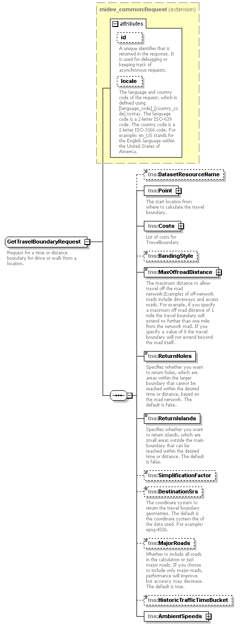
| children | tns:DatasetResourceName tns:Point tns:Costs tns:BandingStyle tns:MaxOffroadDistance tns:ReturnHoles tns:ReturnIslands tns:SimplificationFactor tns:DestinationSrs tns:MajorRoads tns:HistoricTrafficTimeBucket tns:AmbientSpeeds | ||||||||||||||||||||||
| used by |
|
||||||||||||||||||||||
| attributes |
|
||||||||||||||||||||||
| description |
|
element GetTravelBoundaryRequest/DatasetResourceName
| diagram |

|
||||||
| namespace | http://www.mapinfo.com/routing/service/v1 | ||||||
| type | xsd:string | ||||||
| properties |
|
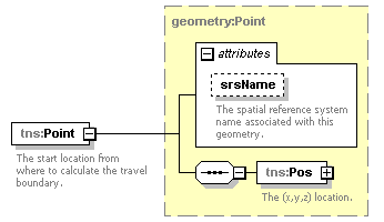
element GetTravelBoundaryRequest/Point
| diagram |
|
||||||||||||||
| namespace | http://www.mapinfo.com/routing/service/v1 | ||||||||||||||
| type | tns:Point | ||||||||||||||
| properties |
|
||||||||||||||
| children | tns:Pos | ||||||||||||||
| attributes |
|
||||||||||||||
| description |
|
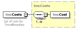
element GetTravelBoundaryRequest/Costs
| diagram |
|
||
| namespace | http://www.mapinfo.com/routing/service/v1 | ||
| type | tns:Costs | ||
| properties |
|
||
| children | tns:Cost | ||
| description |
|
element GetTravelBoundaryRequest/BandingStyle
| diagram |

|
|||||||||||||
| namespace | http://www.mapinfo.com/routing/service/v1 | |||||||||||||
| type | tns:BandingStyle | |||||||||||||
| properties |
|
|||||||||||||
| facets |
|
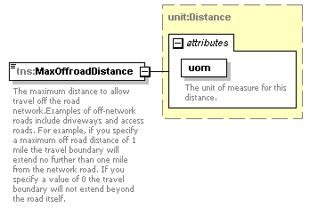
element GetTravelBoundaryRequest/MaxOffroadDistance
| diagram |
|
||||||||||||||
| namespace | http://www.mapinfo.com/routing/service/v1 | ||||||||||||||
| type | tns:Distance | ||||||||||||||
| properties |
|
||||||||||||||
| attributes |
|
||||||||||||||
| description |
|
element GetTravelBoundaryRequest/ReturnHoles
| diagram |
|
||||
| namespace | http://www.mapinfo.com/routing/service/v1 | ||||
| type | xsd:boolean | ||||
| properties |
|
||||
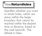
| description |
|
element GetTravelBoundaryRequest/ReturnIslands
| diagram |
|
||||
| namespace | http://www.mapinfo.com/routing/service/v1 | ||||
| type | xsd:boolean | ||||
| properties |
|
||||
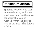
| description |
|
element GetTravelBoundaryRequest/SimplificationFactor
| diagram |

|
|||||||||
| namespace | http://www.mapinfo.com/routing/service/v1 | |||||||||
| type | tns:simplificationFactor | |||||||||
| properties |
|
|||||||||
| facets |
|
element GetTravelBoundaryRequest/DestinationSrs
| diagram |
|
||||||
| namespace | http://www.mapinfo.com/routing/service/v1 | ||||||
| type | xsd:string | ||||||
| properties |
|
||||||
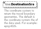
| description |
|
element GetTravelBoundaryRequest/MajorRoads
| diagram |
|
||||||||
| namespace | http://www.mapinfo.com/routing/service/v1 | ||||||||
| type | xsd:boolean | ||||||||
| properties |
|
||||||||
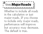
| description |
|
element GetTravelBoundaryRequest/HistoricTrafficTimeBucket
| diagram |

|
||||||||||||||||||||||||||||
| namespace | http://www.mapinfo.com/routing/service/v1 | ||||||||||||||||||||||||||||
| type | tns:HistoricTrafficTimeBucket | ||||||||||||||||||||||||||||
| properties |
|
||||||||||||||||||||||||||||
| facets |
|
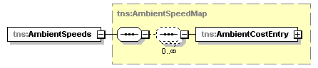
element GetTravelBoundaryRequest/AmbientSpeeds
| diagram |
|
||
| namespace | http://www.mapinfo.com/routing/service/v1 | ||
| type | tns:AmbientSpeedMap | ||
| properties |
|
||
| children | tns:AmbientCostEntry |