Overview
Spectrum Spatial Analyst is an interactive mapping service provided by Pitney Bowes Inc. It provides access to mapping and geographic-based information, addresses and postcode searches. The image given below shows the desktop and mobile view of Spectrum Spatial Analyst application.
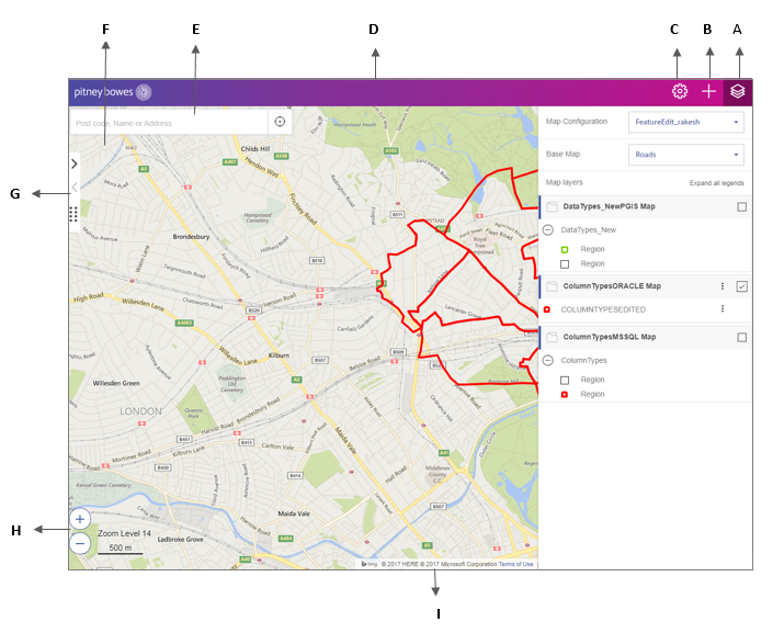
| Item | Name | Description |
|---|---|---|
| A | Map Legend Panel | The Map legends panel allows you to show a key to the map overlays available on your map. Read more. |
| B | Add Panel | The Add panel allows you to perform, query, add thematics layers, create annotation and provide measurement tools. |
| C | Options Panel | The Options panel allows you to print map, view current coordinates, access help, change language, sign-in to the application, launch template designer and open the project home page to create new map project. |
| D | Banner (optional) | This displays the banner of the organization. |
| E | Search Addresses |
The search box to search for an address, place name and ZIP code. Read more. |
| F | Map Area | This is the visible area of the current map. |
| G | Expand/collapse left panel | This button allows you to expand or collapse left hand panel. |
| H | Zoom In and Out (Desktop only) |
Click the Zoom in button on the lower left corner to zoom in to the map. Click the Zoom out button on the lower left corner to zoom out of the map. |
| I | Copyright Information | The copyright information is displayed on the lower right hand corner of the map. Read more. |
Spectrum Spatial Analyst application allows you to:
- Browse current maps and data
- Switch between different background maps such as aerial maps and road maps
- Zoom in and zoom out of maps
- Search and find addresses and postcodes
- Get information about what's on the map by clicking the map
- Search for what services and facilities are nearby to an address
- Search for data within the current map or in a shape you draw
- Search for data using various criteria
- Draw annotations on the map
- Print maps to a PDF file
- Retain X, Y, View and Zoom on switching Map Project, if the projections are same.