To install the MapInfo Stratus Uploader:
-
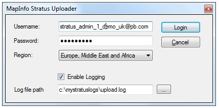
Enter full path to the file where the log has to be written in Log file path
text box or click on the Ellipsis (…) button to select existing directory where log
file has to be created. By default, uploader logs the messages to
%APPDATA%\MapInfo\Stratus Map Uploader\log\messages.svclog.
Note: This logging setting will be effective for a single upload only. Enabling logging can make the upload process slow. You should enable it for troubleshooting purpose only as and when required.Figure 1. MapInfo Stratus Uploader – Login
Note: If you lose any of these details, please contact Pitney Bowes Software Technical Support -
Click Login.
The MapInfo Stratus Uploader dialog box appears. Each layer in the current map window is listed in this dialog box.Figure 2. MapInfo Stratus Uploader – Map Name

-
Click Select All to upload all the layers listed under the Map Layers.
Note: The account name is displayed above the progress bar.Points to Remember
- For layers which are not already in MapInfo Stratus, the check box will always be selected and that can’t be cleared and the data will be uploaded. When a map layer already exists in MapInfo Stratus, select the Upload check box to determine whether you want to upload that layer again to overwrite the data in MapInfo Stratus.
- You can include the same layers in more than one map. You only need to upload the data the first time if the data has not changed.
- Layer types that cannot be uploaded into MapInfo Stratus are indicated with a cross
in the Status column next to the applicable layer name. The Upload check
box will be disabled.Figure 3. MapInfo Stratus Uploader – Status

Note: Hover over the name to display text explaining why the layer cannot be uploaded.
- The following are not supported in tab files:
- Tables that contain special reserved words in their column names. See Appendix A for a list.
- Tables that are in an unsupported projection. See Appendix B for a list.
- Tables that have one or more geometries comprising more than 200,000 nodes are unsupported. To upload such tables you should first use MapInfo Professional to split the geometries into smaller ones so that any individual geometry is under 200,000 nodes. A smaller node count ensures faster performance when rendering maps.
- Tables files containing the following geometries:
- Collection (e.g. a geometry comprised of a polygon + a line + a point)
- Multi-Point
- Text
- Ellipse
Note: A tab file containing a "smoothed line string" will upload successfully but the map will render the line string with no smoothing applied.
To proceed with the upload, close the MapInfo Stratus Uploader, remove all unsupported layers from the MapInfo Professional map window and restart the MapInfo Stratus Uploader.
- Messages are displayed in the Progress column next to the layer being processed showing the current upload status for that layer.
- At the bottom of the dialog box progress bar indicates the progress of the upload operation and information is displayed about the current processing status.
- You can halt the operation by clicking the Cancel button.
When the upload is complete, it is indicated on the dialog box.
Figure 4. MapInfo Stratus Uploader – Progress
