The Reverse Geocoding category provides options that let you set searching and
matching criteria. The following sections cover the reverse geocoding global defaults options, which are available for all countries, and the
country-specific reverse geocoding options, which apply to
a subset of countries.
Global Defaults in Management Console
You can create overrides for the global default options on a per-country
basis. These options have a  next to the Country column value. For more
information about how to create overrides, see Setting Country Overrides.
next to the Country column value. For more
information about how to create overrides, see Setting Country Overrides.
If you modify a global defaults option,
then that selection is applied to all countries and cannot be
changed on a per-country basis. Subsequently, if you select a
country and view its options, the modified global defaults option
will be inactive in the GUI.
| Option Name |
Country Support |
Description |
| Search Distance |
All |
Sets the distance of the radius in which to search
for a match to the input coordinates. This value can be specified in
either feet or meters. Default = 150 meters. Maximum value = 5280
feet (1 mile) or 1609 meters. |
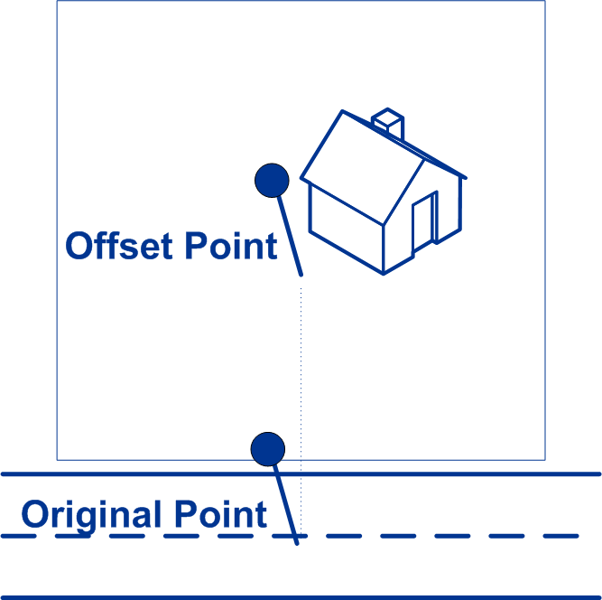
| Street Offset |
All |
- Specifies the offset distance from the
street segments to use in street-level geocoding. The
offset distance is used in street-level geocoding to
prevent the geocode from being in the middle of a
street. It compensates for the fact that street-level
geocoding returns a latitude and longitude point in the
center of the street where the address is located. Since
the building represented by an address is not on the
street itself, you do not want the geocode for an
address to be a point on the street. Instead, you want
the geocode to represent the location of the building
which sits next to the street.
For example, an offset
of 50 feet means that the geocode will represent a
point 50 feet back from the center of the street.
The distance is calculated perpendicular to the
portion of the street segment for the address.
Offset is also used to prevent addresses across the
street from each other from being given the same
point. Default value = 7 meters.
The
following diagram shows an offset point in relation
to the original point.
 You can select either Feet or Meters for your
unit of measurement.
|
| Corner Offset |
All |
- Specifies the distance to offset the
street end points in street-level matching. This value
is used to prevent addresses at street corners from
being given the same geocode as the intersection.
Defines the offset position of the geocoded point with
respect to the corner. Default value = 7 meters.
The
following diagram compares the end points of a
street to offset end points.

You can select either Feet or Meters for your unit of
measurement.
|
| Coordinate System |
All |
Specifies the coordinate system that you want to convert the
geometry to. The format must be the European Petroleum Survey Group
(EPSG) code or the SRID code. Default = epsg:4326. |
County-Specific Reverse Geocoding Options
| Option Name |
Country Support |
Description |
| Find Options |
USA |
These options set the constraints to use when matching.
- Nearest Address
- Attempts to match to the nearest address. Default =
enabled.
- Nearest Intersection
- Attempts to match to the nearest intersection match.
Default = disabled.
- Nearest Unranged Segment
- Attempts to match to the nearest unranged segment.
Default = disabled.
- Prefer Match to Closest
Point
- Attempts to match to the nearest
point address within the search radius, rather than to
the closest feature (e.g. street segment or intersection
as well as point addresses). Default =
disabled.
Note: This feature requires that at least
one points dataset and one streets dataset are
loaded; otherwise, the match will be made to the
closest feature.
|
| Keep Multiple Matches |
USA |
Sets the maximum number of match candidates
to be returned.
- Enabled
- Return all match candidates.
- Disabled
- Return only the best match candidate. Default.
|