Geocode GET Request
The GET request enables you to submit an input address and matching and/or geocoding preferences to the Geocode service and receive a response that provides the candidates object which contains the associated latitude/longitude coordinates and other matching and location information about each candidate. The preference options for a GET request are a subset of the total available with the POST request.
Base URI
http://<server>:<port>/rest/GlobalGeocode/geocode[.content type]where:
- json
- Default content type is JSON, unless superseded by HTTP content negotiation
- xml
- Default content type is XML, unless superseded by HTTP content negotiation
[query parameters] are described in the following section. Each key/value pair entered in the request is separated by an ampersand.
Query Parameters
The following table defines the GET query parameters for the Geocode service. For information on the response, see GeocodeServiceResponse Object.
| Parameter | Type | Description |
|---|---|---|
| placeName | String | Building name, place name, Point of Interest (POI), company or firm name
associated with the input address. Optional. For example:
Pitney Bowes |
| mainAddress | String | Single Line input—If no other field is populated, then the
mainAddress entry will be treated as a single line input and
can be a collection of address field elements. The input order of the address fields
should reflect the normal address formatting for your country. Optional. For
example: 4750 Walnut St., Boulder CO, 80301 Street Address—If the address fields (placeName, lastLine, postalCode, etc.) are provided separately, then the content of this field will be treated as the street address part and can include company name, house number, building names and street names. Optional. Street Intersection Input—To enter an intersection, specify the two street names separated by a double ampersand (&&). |
| lastLine | String | The last line of the address. Optional. |
| areaName1 | String | Specifies the largest geographic area, typically a state or province. Optional. |
| areaName2 | String | Specifies the secondary geographic area, typically a county or district. Optional. |
| areaName3 | String | Specifies a city or town name. Optional. |
| areaName4 | String | Specifies a city subdivision or locality. Optional. |
| postalCode | String | The postal code in the appropriate format for the country. Optional. |
| country | String | ISO 3166-1 alpha-3 country code. Required. For country codes, see Country Reference Listing and ISO 3166-1 Country Codes. |
| matchMode | String | Match modes determine the leniency used to make a match between the input
address and the reference data. Select a match mode based on the quality of your
input and your desired output. The following match modes are available:
|
| fallbackGeo | Boolean | Specifies whether to attempt to determine a geographic region
centroid when an address-level geocode cannot be determined. Optional.
|
| fallbackPostal | Boolean | Specifies whether to attempt to determine a post code centroid
when an address-level geocode cannot be determined. Optional.
|
| maxCands | Integer | The maximum number of candidates to return. Optional. Must be an integer value. Default = 1. |
| streetOffset | Double | Indicates the offset distance from the street segments to use in street-level
geocoding. The distance is specified in the units you specify in the
streetOffsetUnits option. Default value = 7 meters. The offset distance is used in street-level geocoding to prevent the geocode from being in the middle of a street. It compensates for the fact that street-level geocoding returns a latitude and longitude point in the center of the street where the address is located. Since the building represented by an address is not on the street itself, you do not want the geocode for an address to be a point on the street. Instead, you want the geocode to represent the location of the building which sits next to the street. For example, an offset of 50 feet means that the geocode will represent a point 50 feet back from the center of the street. The distance is calculated perpendicular to the portion of the street segment for the address. Offset is also used to prevent addresses across the street from each other from being given the same point. The following diagram shows an offset point in relation to the original point. 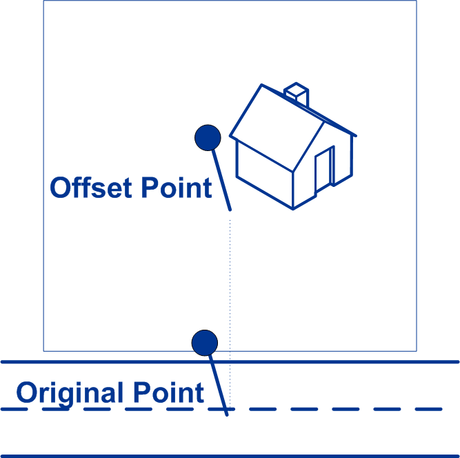 |
| streetOffsetUnits | String | Specifies the unit of measurement for the street offset. One of the following:
|
| cornerOffset | Double | Specifies the distance to offset the street end points in street-level
matching. The distance is specified in the units you specify in the
cornerOffsetUnits option. This value is used to prevent addresses at street corners
from being given the same geocode as the intersection. Defines the offset position
of the geocoded point with respect to the corner. Default value = 7 meters. The following diagram compares the end points of a street to offset end points. 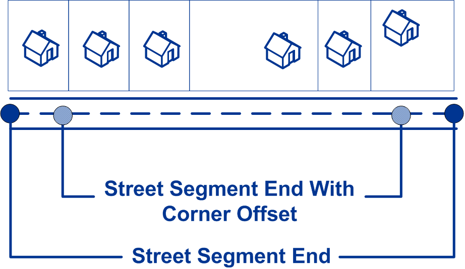
|
| cornerOffsetUnits | String | Specifies the unit of measurement for the corner offset. One of the following:
|